Yearly archives: 2020
205 posts


Alex Orenstein sent us this pic of a massive model of the city of Lyon. “Model of Lyon also functions as a climate catastrophe flood simulator when it rains. Neat!”

Angharad Stone sent me this pic of a massive mirror with a map of the world on it from Le Vignoble, a new wine bar in Bristol.
WTF is he thinking of? You may well ask. Thierry Gregorius sent me this pic and I would probably have smiled and not bothered to upload it as it isn’t a Map in the Wild but then Ed Parsons chipped in on twitter with this gem of dry wit I […]
A really great sentiment! I really like the way the streets and green spaces are the background to the image.
Reinder Storm sent us these pix of an electricity substation in The Hague, Netherlands, that is neatly decorated with street maps. “Cartographically inspired painting of a #electrichouse on the Lange Beestenmarkt in @GemeenteDenHaag @GekopKaarten @MapsintheWild Maps always maps everywhere Irresistible”

Reinder Storm sent us this pic of a cow with the world on it which he spotted in the window of a house in The Hague, Netherlands. I am not sure what projection this is?

Russ sent us this pic “The US Naval Memorial has the whole world etched into the ground. Of course, the polished stone is the world’s bodies of water.”

Gretchen Peterson shared this Boston map from a hotel stay “The decorator for this hotel must be familiar with cartography twitter. I’m impressed (despite it appearing to be unprojected).”

Tom Armitage shared these pics of a map trail embedded in the pavement. “Map of the Water of Leith inlaid into the pavement at the Leith end of the walkway to Balerno. “ Here is another part of the path from Saughton Park courtesy of the Friends of Saughton

Another one from Cartonaut, this time from the Nimbus Fish Hatchery. “Light illuminated animation showing how dams drastically reduced salmon and steelhead spawning grounds. Nimbus Fish Hatchery, American River Given that it is the dry season, this may serve dual duty as statement and metaphor.”
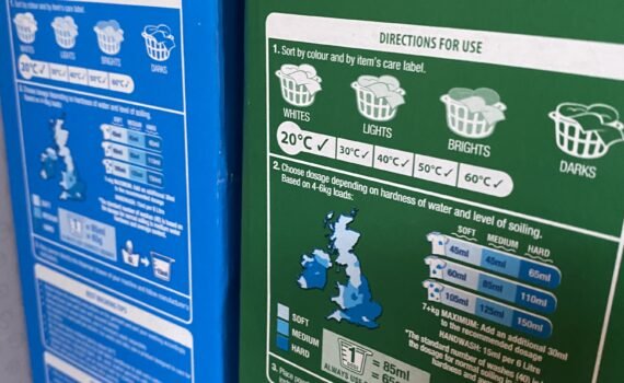
Andrew Newman sent me topic from his laundry shelf. The map on the detergent box shows the different water hardness zones for the British Isles and indicates how much detergent to use.
Definitely not a map in the wild but still a rather neat map via Mathieu “Due to the overwhelming attention for my emoji card, I have performed an upgrade With glossy main roles for, among others, @AFCAjax @NS_online @Thialf @Schiphol @centraal_beheer @Brainport_ehv @Efteling @PhilipsNL @hermanfinkers @npoosterschelde and @PortOfRotterdam”