Jory Fleming sent us this sweet little hand drawn map for a rare book walk around Oxford colleges. “Was given this hand drawn map done by the librarian at Wadham College, for a rare book tour some colleges put on.” Is it wild? Well it’s hand-held and I can see […]
Yearly archives: 2018
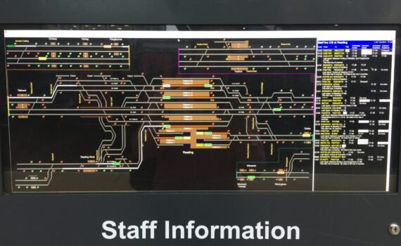
Andrew Newman sent us this pic of a line and signal schematic at Reading Station. “You may or may not consider this map to be a map, but it’s useful and in the wild.” I’m not sure about these railway schematics, this is the second one we’ve been sent so […]
Dave Lovell, who is currently our most prolific contributor sent us these pics of the globe sculpture in Seattle Fish Market. “Seattle Fish market (don’t ask me why) 2014” And yes, it really is a working fish market.
This geological map of France was sent to us by Dave Lovell I love a map that you can walk on. 2008 was the International Year of Planet Earth and this map was exhibited in Paris outside of the Natural History Museum, there was also a superb display panel advertising the […]
I saw this example on a recent journey through Canterbury airport, New Zealand. As I wandered through the departure area I naturally thought the patterns on the carpet looked like a map then when you look at the vast expanse rolled out in front of you it becomes obvious it […]
Jez Nicholson sent us this pic of The Gallery of Maps in the Vatican I wouldn’t be surprised if we get several more of these but they will need to be creative to get posted.
Jeremy Bolwell sent us this map of Wales “This map of Wales dates from when Attingham Hall was a college, I think. I have always considered it a good idea to paper maps to walls – the scale needs to be right but it gives insights into the geography of […]
Paul Hardy sent us this picture of a map of Roman Bedford “Here’s another map in the wild. It’s in the centre of Bedford (UK), and the photo is taken looking down from the remains of the medieval castle mound. The map is of Bedford in Roman times. It would […]
David Overton of SplashMaps sent us this pic of a splash map in use in the Peruvian jungle. “Deep in the Peruvian rain forest the Norwegian military were in charge of navigation, using SplashMaps to navigate the Yaku river in particular while delivering aid and support to remote villages.” I […]
Charles Kennelly sent us this magnificent map pic of the Heian Jingu shrine in Kyoto “Heian Jingu shrine in Kyoto, this is the map at the entrance to the shrine and its gardens. A beautiful and functional and human map of the site as it is today. But what I found […]
Ant Scott sent us this pic from a recent MapAction deployment “I came across this one while out on a damage assessment visit yesterday for MapAction following the recent Sulawesi earthquake. I don’t remember seeing maps on election posters before, let alone with classes and a legend, showing (I believe) […]
Dan Ormsby sent us this schematic map “A schematic map hanging in the signal box of a railway station in central Sri Lanka showing the lines, signalling equipment, engine sheds etc. The signalling equipment is the original equipment installed by the British when the railways were build (around the 1860’s) […]
In Belem just on the outskirts of Lisbon is the Padrão dos Descobrimentos or Monument of the Discoveries commemorating the great explorers of Portugal’s past. In front of the monument is this amazing marble map detailing the extent of the Portuguese empire at its peak. Dave Lovell sent me this beautiful pic that […]
Originally posted on Twitter by David McCutcheon, this wonderful old record was found languishing in an Oxfam shop and picked up by David for a paltry £3 which has to be worth it for the fantasy map artwork adorning the cover.
Caitlin Dempsey, the editor of GisLounge sent us this beauty “One of my favorite hidden gems at the Los Angeles Farmer’s Market is the “Travel Angel” which was installed in 2001 as part of a public art project. The piece is kind of hidden in a nook near one of the […]


